


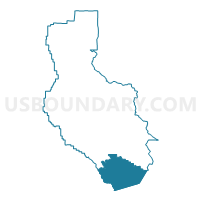
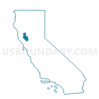
Voting District 10011, Lake County, California
About
Outline

Summary
| Unique Area Identifier | 532486 |
| Name | Voting District 10011 |
| County | Lake County |
| State | California |
| Area (square miles) | 127.07 |
| Land Area (square miles) | 126.23 |
| Water Area (square miles) | 0.84 |
| % of Land Area | 99.34 |
| % of Water Area | 0.66 |
| Latitude of the Internal Point | 38.75277420 |
| Longtitude of the Internal Point | -122.55719620 |
Maps

Graphs
Select a template below for downloading or customizing gragh for Voting District 10011, Lake County, California


Neighbors
Neighoring Voting District (by Name) Neighboring Voting District on the Map
- Voting District 10010, Lake County, CA
- Voting District 30230, Napa County, CA
- Voting District 30255, Napa County, CA
- Voting District 30290, Napa County, CA
- Voting District 30305, Napa County, CA
- Voting District 40955, Sonoma County, CA
- Voting District 40960, Sonoma County, CA
- Voting District 50094, Lake County, CA
Top 10 Neighboring County Subdivision (by Population) Neighboring County Subdivision on the Map
- Cloverdale-Geyserville CCD, Sonoma County, CA (13,648)
- Middletown CCD, Lake County, CA (7,575)
- Calistoga CCD, Napa County, CA (6,448)
- Cobb CCD, Lake County, CA (3,865)
- Lower Lake CCD, Lake County, CA (3,198)
- Lake Berryessa CCD, Napa County, CA (1,806)
Top 10 Neighboring Place (by Population) Neighboring Place on the Map
Top 10 Neighboring Elementary School District (by Population) Neighboring Elementary School District on the Map
- Alexander Valley Union Elementary School District, CA (871)
- Pope Valley Union Elementary School District, CA (791)
Top 10 Neighboring Unified School District (by Population) Neighboring Unified School District on the Map
- Konocti Unified School District, CA (22,639)
- Middletown Unified School District, CA (10,050)
- St. Helena Unified School District, CA (9,714)
- Calistoga Joint Unified School District, CA (7,173)
- Geyserville Unified School District, CA (1,750)
Top 10 Neighboring State Legislative District Lower Chamber (by Population) Neighboring State Legislative District Lower Chamber on the Map
Top 10 Neighboring State Legislative District Upper Chamber (by Population) Neighboring State Legislative District Upper Chamber on the Map
Top 10 Neighboring 111th Congressional District (by Population) Neighboring 111th Congressional District on the Map
Top 10 Neighboring Census Tract (by Population) Neighboring Census Tract on the Map
- Census Tract 13, Lake County, CA (7,575)
- Census Tract 11, Lake County, CA (3,865)
- Census Tract 1541, Sonoma County, CA (3,729)
- Census Tract 12, Lake County, CA (3,198)
- Census Tract 2018, Napa County, CA (1,806)
- Census Tract 2019, Napa County, CA (1,293)
Top 10 Neighboring 5-Digit ZIP Code Tabulation Area (by Population) Neighboring 5-Digit ZIP Code Tabulation Area on the Map
- 95448, CA (16,852)
- 95425, CA (10,841)
- 94515, CA (7,050)
- 95467, CA (5,498)
- 95461, CA (3,413)
- 95457, CA (2,893)
- 95426, CA (2,147)
- 94567, CA (623)